last update 2005/05/29
We have been developing algorithms such as for calibrating crop models using RS data through data assimilation, monitoring actual irrigation, counting number of cropping, discriminating crop types and etc (publication). The RS data used is mainly NDVI time series data from low to moderate resolution satellites which is useful to monitor and analyze crop dynamics, such as 10days SPOT Vegetation Instrument Data, 8 days or 16days MODIS data.
However, even the data is the composite of several or more days' data, the
data is still not free from the influence of cloud cover. Pixels may have been covered
by clouds partially or totally covered by thin clouds which usually reduces the
value of NDVI.
ANDES project (AFFRC
1998, JST
1998 ) as a part of "Research and Development for Applying
Advacned Computational Science and Technology" or ACT-JST has developed LMF algorithm ( LMF stands for Local Maximum Fitting
) (SAWADA,H. 2001,
NAGATANI
et. al. 2002 ). The detail algorithm can be found in SAWADA 2002. The algorithm
firstly finds local maximums within a certain time window, and regenerate
the time series data as a sum of harmonic curves. The number of harmonic curves
is limited by AIC ( Akaike Information Criterion ) to avoid over-fitting. The
detail is in Lecture note on LMF and NN
of Advanced RS course of AIT.
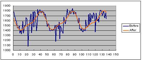
An example of LMF processed MODIS 8 days NDVI at Suphanburi Province in
Thailand.
column=22, line=35 in the sample image included in the distribution.
NDVI is being scaled from 0-2000. The base wavelenth of the harmonic curve is 1
year, thus the same pattern repeats 3 times for 3 years data like above (The
trend is being considered). The window size of the local maxim filter is
6(NWIN=3).
Almost of source codes ( FORTRAN ) are available from the project home page (in Japanese), however, the codes are for unix+Fortran77(OpenMP) and the binaries are for SGI. We have modified the program for NDVI by adding a subroutine and removing interfaces to multiple processors. Now, the code can be compiled under common environment; LINUX(f77) and Windows (Visual Fortran). We have obtained an approval from JST, and made the code and executable downloadable from this site.
Download Source Code and Executable: ( LINUX , Windows
)
The software is being distributed as it is. "ACT-JST"
must be referred for re-distribution and publishing the result.
The zip file includes source, executable and sample data. You will find data directory where you can just run the executable to test the
LMF using small 8 days MODIS NDVI data although it may take 20 minutes on Pentium
M 1.1
GHz. You have to change
cntl.dat to process your own data.
We have applied the LMF on 8 days NDVI of MODIS in a project "Near Real Time Agriculture Activity Monitoring using Multi-Temporal MODIS Earth Observation Satellite Data"
supported by RTG (Royal Thai Government) - AIT joint research fund. We have
organized a seminar to disseminate research result including LMF to Thai
researchers on 28th-29th April, 2005 at Faculty of Engineering, Kasetsart
University, Bangkok, Thailand.( photos
)
Download Distributed Material (Coming Soon).
Our team is utilizing cluster computers for our research especially data assimilation. If you are interested in installing clusters, or GRID, we may have collaboration.
REFERENCES
SAWADA, H., SAWADA, Y., 2002, Development of Seasonal Change Model of
Vegetation from High-frequency Observation Satellite Data, Environmental
Information Science, No. 16, pp.181- 185, 200, Center for Environmental
Information Science, Tokyo ( in Japanese )
SAWADA, H.,
2001, Asia-Pacific network for disaster mitigation using Earth Observation
Satellite (ANDES), October 1, 1998-September 30, 2001. Department of Global,
Forest Research Forestry and Forest Products Research Institute, Ibaraki,
Japan., Available online at: http://www.affrc.go.jp/ANDES/sawady/index.html
NAGATANI, I., SAITO, G., TORITANI, H. and SAWADA, H., 2002, Agricultural map of Asian region using time series AVHRR NDVI data. In Proceedings Online of the 23rd Asian Conference on Remote Sensing, 25-29 November 2002, Birendra International Convention Centre in Kathmandu, Nepal. Available online at: http://www.gisdevelopment.net/aars/acrs/2002/pos2/184.pdf
AFFRC, 1998, ANDES Asia-Pacific Network for Disaster Mitigation Using Earth Observation Satellite, Available online at: http://www.affrc.go.jp/ANDES/ ( AFFRC: Agriculture, Forestry and Fisheries Research Council )
JST, 1998, Asia-Pacific Network for Disaster Mitigation Using Earth Observation Satellite (ANDES), Available online at: http://act.jst.go.jp/content/h10/ter_cosm/T04/PageMain_e.html
OUR PUBLICATIONS RELATED TO AGRICULTURE
MONITORING
On quantifying agricultural and water management practices from low spatial resolution RS data using genetic algorithms: A numerical study for mixed pixel environment: Amor
V.M. Ines, Kiyoshi Honda: Advances in Water Resources , in press ( available on Web ), 2005
Genetic algorithm for Assimilating Remotely Sensed Evapotransiration Data using a Soil-Water-Atmosphere-Plant Model -Implementation Issues: Yann
Chemin, Kiyoshi Honda and Amor V. Ines: International Journal of Geoinformatics ISSN 1686-6576, pp.87-90, Vol. 1, No. 1, March, 2005
Discrimination of Irrigated and Rainfed Rice in a Tropical Agricultural System using SPOT-VEGETATION NDVI and Rainfall Data: Daroonwan
Kamthonkiat, Kiyoshi Honda, Hugh Turral, Nitin K. Tripathi, Vilas Wuwongse: International Journal of Remote Sensing , Proof Reading, 2005
Genetic algorithm for assimilating remotely sensed evapotransiration data using a soil-water-atmosphere-plant model. Implementation issues: Yann
Chemin, Kiyoshi Honda, Amor V.M. Ines: Open Source Free Software GIS - GRASS users conference,
http://gisws.media.osaka-cu.ac.jp/grass04/viewpaper.php?id=27, 2004
A Look Up Table Method for Data Assimilation in Crop Model Parameter Identification - Application in Quantifying Agricultural Practices in a Mixed Pixel Environment -: Kiyoshi Honda, Amor
V.M. Ines: Proceedings of the 25th Asian Conference on Remote Sensing, 22-26, November 2004, Chiang Mai, Thailand, pp.1330-1334, 2004
Real-Time Building Identification System Development Using Aerial Imagery: Duong Van
HIEU, HONDA Kiyoshi: Proceedings of the 25th Asian Conference on Remote Sensing, 22-26, November 2004, Chiang Mai, Thailand, pp.1620-1625, 2004
SWAP Crop Model Pramaeter Identification using SPOT Vegetation in Suphanburi, Thailand: Panithan
Srinuandee, Kiyoshi Honda, Yann Chemin, Amor V.M. Ines: Proceedings of the 25th Asian Conference on Remote Sensing, 22-26, November 2004, Chiang Mai, Thailand, pp. 391-396, 2004
Characteristics of NDVI Fluctuation Pattern at Irrigated and Non-Irrigated Rice in Different Climate Zones in Thailand: Daroonwan
Kamthonkiat, Honda Kiyoshi, Turral Hugh, Nitin K. Tripathi, Vilas Wuwongse: Proceedings of the 25th Asian Conference on Remote Sensing, 22-26, November 2004, Chiang Mai, Thailand, pp.563-568, 2004
Genetic Algorithms in Quantifying Water Management and Agricultural Practices at the Sub-Pixel Level: Kiyoshi Honda, Amor
V.M. Ines: Proceedings of the 6th International Conference on Hydroinformatics, Volume 2, pp. 1319-1325, 2004
Use of RS in Quantifying Irrigation Water Management Based on Data Assimilation Technique: HONDA Kiyoshi: 2003 International Symposium on the Climate System of Asian Monsoon and its Interaction with Society, Khon
Kaen, Thailand, 11-13, November, , 2003
Real Coded Genetic Algorithm for Assimilating Remotely Sensed Evapotransiration Data Using a Soil-water-atmosphere-plant Model. A Methodology: Yann
Chemin, Kiyoshi Honda and Amor Ines: AFITA/WCCA2004, vol. 2, pp. 933-938, 2003
Stochastic Data Assimilation Technique in Regional Hydrology:
A.V.M. Ines, P. Droogers, K. HONDA and A.D. Gupta : Geographical Research Abstract, vol.5, 03232, 2003
Exploring water management options using Genetic Algorithms: A case study of Bata Minor,
Kaithal, Haryana, India: A.V.M. Ines, R.Clemente, P.Droogers, A.D. Gupta and K. HONDA: Proceedings of the 1st International Conference on Hydrology and Water Resources in Asia Pacific Region, vol.2, pp. 933-938, 2003
A Numerical Experiment in Assimilating Agricultural Practices in a Mixed Pixel Environment using Genetic Algorithms: Kiyoshi HONDA, Amor V. M.
Ines: Proceedings of the 24th Asian Conference on Remote Sensing, 3-7, November 2003,
Busan, Korea, CD-ROM (WB2 Agriculture 1), 2003
Time Series Analysis of SPOT VEGETATION Instrument Data for Identifying Agricultural Pattern of Irrigated and Non-irrigated Rice Cultivation in Suphanburi Province, Thailand: Daroonwan
Kamthonkiat, Honda Kiyoshi, Turral Hugh, Nitin K. Tripathi, Vilas Wuwongse: Proceedings of the 24th Asian Conference on Remote Sensing, 3-7, November 2003,
Busan, Korea, CD-ROM (WB2 Agriculture 2), 2003